States
Leadership
Resources
Contact Us
News
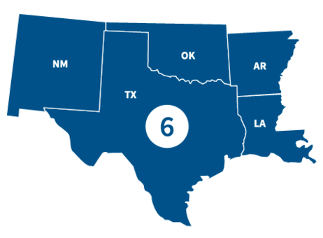
FEMA Region 6 office, located in Denton, TX, partners with federal emergency management for 68 Tribal Nations and the following states.
States
Visit the state's page for localized content, such as disaster recovery centers, flood maps, fact sheets, jobs and other resources.
Leadership

Acting Regional Administrator

Acting Deputy Regional Administrator
Region 6 Resources

Featured Resource
Risk Communications Guidebook for Local Officials
Find customizable templates and additional tools to support your Risk MAP outreach. Download the Resource Matrix for all Guidebook templates.
Get the Guidebook
Use the search filters below to browse content tailored to help Region 6 prepare for, respond to and recover from disasters.
Updating flood maps can be a multi-year effort and providing community review of the maps before they go effective is an important part of the process.
FEMA works with communities to provide information and resources online to view the preliminary flood insurance rate maps. It’s important for property owners to understand options if they need to consider flood insurance, or if they disagree with the maps.

Visit the Community Members' Guide to Initiating Map Revisions to see our online resources, as well as upcoming dates for in-person and online Flood Risk "Open Houses," which are opportunities to ask FEMA your flood risk questions.
This quick guide provides audiences with an overall summary of the Guidebook, including the various resources and tools available to use.
Customize this template for an informative brochure to give to residents and business owners. It tells them about the Risk MAP process and how it could affect their flood risk.
The Mitigation Funding Resource Guides provide state, territory, and local officials with a wide array of potential mitigation funding resources. These resources include grants, loans, technical assistance, and in-kind services from federal, state, territory, and private sources.
Each resource includes information about the program, eligibility requirements, cost sharing, and an example of program use, if available. The Guides also align the resource with the National Mitigation Framework core capability and the National Disaster Recovery Framework support function.
Download Mitigation Funding Guides by State
Customize this template to make a detailed plan for outreach during the Post-Preliminary phase. It suggests outreach tactics, news releases, public service announcements, talking points, and social media posts.
Contact Us
General
940-898-5399
Grants
FEMA-R6-Grants-Inquiry@fema.dhs.gov
Exercise Officer
FEMA-R6-Exercise@fema.dhs.gov
News Desk
940-898-5454
FEMA-R6-NewsDesk@fema.dhs.gov
Technological Hazards
Oscar Martinez
FEMA-R6-REPP@fema.dhs.gov
Tribal Affairs
FEMA-R6-Tribal-Affairs@fema.dhs.gov


