

Guaynabo, PUERTO RICO - As part of Puerto Rico’s resilient recovery from future disasters, strategic planning and reconstruction projects become more important, especially for municipalities with limited resources and social-based nonprofit organizations.
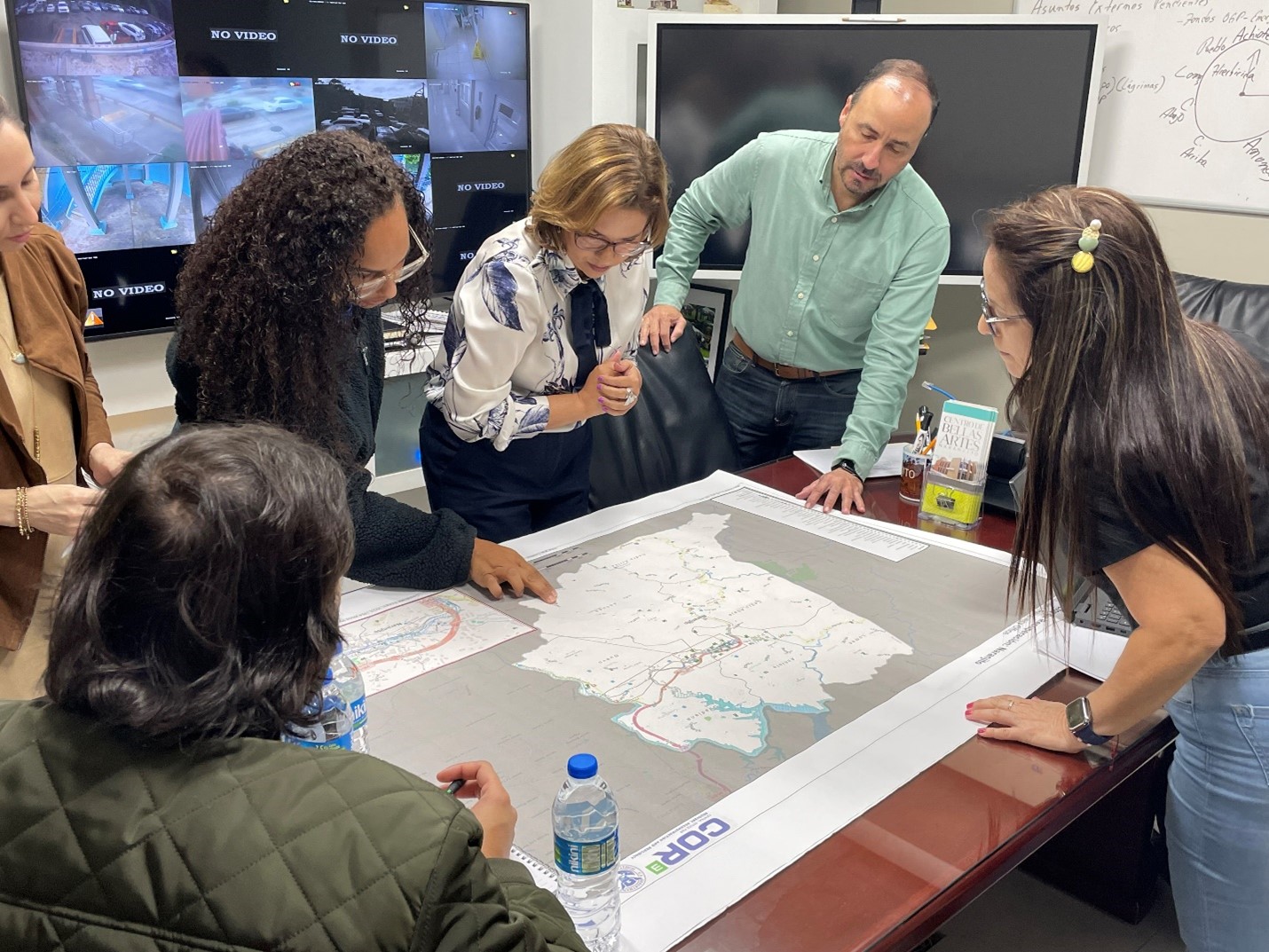
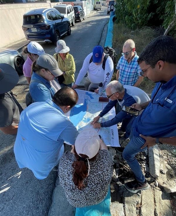
To help expand the technical knowledge of municipalities and these organizations, the Federal Emergency Management Agency (FEMA) held participatory mapping exercises in municipalities around the island to help them identify solutions in their disaster recovery efforts.
Many municipalities lack geographic information systems or need high-resolution printed maps to conduct their planning efforts more effectively. Participatory mapping exercises allow municipal staff to better observe the potential hazards and vulnerabilities that exist around their municipalities and visualize their recovery plans.
“Part of FEMA’s role is to support municipalities and social-based organizations to strengthen their development and capacity. The mapping exercises are a tool to help them be better prepared and more resilient,” said Federal Disaster Recovery Coordinator José G. Baquero.
In the municipality of Ciales, the municipal mapping exercise was essential to identify opportunities to help improve urban and community planning in city revitalization and municipal recovery projects, said planner Aner Cosme Maldonado.
The mapping initiative helped reveal that all Ciales communities experienced vulnerability, particularly the Posas, Cialitos, Toro Negro, Pesas and Frontón neighborhoods. Cosme Maldonado explained that solutions vary according to the needs of each community, which has led to the development of reconstruction projects for critical infrastructure, communal areas and basic water services in all affected zones.
“This has allowed us to make informed decisions on how to improve the quality of life of the people of Ciales, promoting sustainable growth and resilience to disasters, and fostering economic development in the municipality. We have been able to visualize alongside the mayor the needs and potential solutions of each community, facilitating collaboration between different actors and the effective implementation of revitalization projects,” said Cosme Maldonado.
During the mapping exercise, two maps of the municipality or community are used. The maps by neighborhoods and municipal sectors offer a spatial view of the territory, which allows officials to have a holistic vision of their municipality. Then, in a second map, the image is expanded to the urban center, allowing the identification of revitalization projects with economic and social development potential.
As a result of the needs identified by municipalities and organizations, FEMA develops follow-up activities, where municipal officials and experts address problems such as storm runoff management; coastal erosion, riverine flooding, erosion and scour in rivers and streams; and the processes that must be carried out to identify, designate and dispose of structures and lots of land that can be declared public nuisances.
FEMA’s Community Assistance unit has visited over 50 municipalities since 2018 to offer participatory mapping exercises to municipal officials and members of nonprofit organizations. The team bets on the recovery of municipalities and organizations with a visual methodology that has facilitated the understanding, analysis and dissemination of data for the benefit of the regional planning process in the country.
During a participatory mapping exercise, the municipalities of Quebradillas and Lares expressed their need for help in addressing the challenge of the proliferation of disused structures in the urban area. The FEMA group coordinated a meeting between the municipality and the nonprofit organization Centro para la Reconstrucción del Hábitat, in which the municipality’s concerns were discussed and possible solutions were provided.
In Barceloneta, the Community Assistance unit helped the municipality develop a virtual tool to promote local tourism. Using platforms such as Google Earth Pro and Google Maps, the Community Assistance group worked with the municipality’s Public Documents Office and the Ignacio Cruz Báez Cultural Center to digitize areas of tourist interest, information that was then shared on the municipality’s website.
It is estimated that the Regional Approach for Recovery workshop will be held in October, an event that gathers the predominant needs and hazardous situations in the areas visited.
During the event, specific and sustainable recovery alternatives will be offered to the participating municipalities. In the last workshop, issues such as landslides, coastal erosion and mitigation plans were addressed.
For his part, the executive director of the Central Office for Recovery, Reconstruction and Resiliency (COR3), Manuel A. Laboy Rivera, said that, “one of the main objectives of reconstruction is to provide resilience to the infrastructure. The implementation of mapping technology will be key to improving the planning process necessary for the responsible development of works that adapt to community needs and are considered future risks to avoid damage that compromises the stability of critical infrastructure.”
For more information about Puerto Rico’s recovery, visit fema.gov/disaster/4339, fema.gov/disaster/4473 and recovery.pr. Follow us on our social media at Facebook.com/FEMAPuertoRico, Facebook.com/COR3pr and Twitter @COR3pr.
Municipality of Naranjito, Puerto Rico
NARANJITO, Puerto Rico (April 18, 2024) - The Federal Emergency Management Agency (FEMA) held participatory mapping exercises in municipalities around the island to help them identify solutions in their disaster recovery efforts. These exercises allow municipal staff to better observe the potential hazards and vulnerabilities that exist around their municipalities and visualize their recovery plans. In the photo, staff from FEMA and the Municipality of Naranjito review maps of that town. Photo FEMA/Marynet Sánchez
Municipality of Ponce, Puerto Rico
PONCE, Puerto Rico (January 18, 2024) - To help expand the technical knowledge of municipalities and these organizations, the Federal Emergency Management Agency (FEMA) held participatory mapping exercises in municipalities around the island to help them identify solutions in their disaster recovery efforts. Residents of the Municipality of Ponce participated in a mapping exercise in their communities. Photo FEMA