

Cambridge, VT redesigned a flood-prone bridge with FEMA and state grants, solving a human-caused problem.
Decades of Floods
Heavy rains and seasonal snowmelt from the Green Mountains and Smugglers’ Notch, a mountain pass above the Town of Cambridge, cause both the Brewster and Lamoille Rivers to overflow and flood the twin villages below almost annually.
Originally chartered in 1781, the town of Cambridge was established along the south bank of the Lamoille River, nestled in a river valley of the Green Mountains. The town consists of two villages, Cambridge and Jeffersonville. Once called ‘Cambridge Center’, the village of Jeffersonville was renamed to honor Thomas Jefferson in 1827. It sits at the intersection of the Lamoille River and the Brewster River; the combined communities remained relatively isolated until the development of the Burlington and Lamoille Railroad in 1875.
Initially, after the railroad bridge’s installation there was no significant alteration of the typical annual flooding patterns from heavy snowmelt or the atypical rains that affect the villages.
However, that began to change when the original covered rail bridge was replaced in 1968; the replacement structure was a solid steel rail bridge with girders that provided no pass through for the rising waters of the rivers below.
In addition to lowering the ceiling of how high the flood waters could rise; the combined weight and substructure of the new bridge necessitated larger abutments and a shorter bridge span – requiring the banks of the Brewster River to be significantly narrowed, which constricted the natural flow of the river.
Abutment
An abutment is part of the substructure of a bridge span or dam that provides support to its superstructure. Single-span bridges have abutments at each end that provide vertical and lateral support for the span.
When the railway was disbanded in 1994, a decision was made by the State of Vermont to keep the steel bridge over Brewster River and to convert the disused rail line including the steel bridge into part of the Lamoille Valley Rail Trail.
Lamoille Valley Rail Trail (LVRT)
The LVTR is a 93 mile long, all season, multi-purpose recreation and transportation corridor. Residents and visitors use it for walking, hiking, cycling, horseback riding, snowshoeing, cross country skiing, dogsledding, and even snowmobiling. The LVRT connects 18 towns across the northern half of Vermont.
The problems caused by leaving the steel bridge in place were multi-pronged:
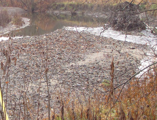
- The narrowing of the river at the abutments created a funnel effect that caused the river to back up, increasing the velocity of the water and sedimentation (when sediment builds up against a barrier) downstream;
- The sedimentation created gravel bars in the river that pushed the water out of its natural channel increasing bank erosion and raising the riverbed thus leading to more overflow events;
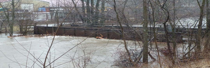
- During high water events, the water ran into the steel girders of the bridge, which essentially acted as one large metal dam, causing the water to back up. This temporary dam eventually pushed the water to the side of the bridge, subsequently contributing to flooding in the lower lying parts of the village of Jeffersonville; and
The railway bridge is parallel to Vermont Route 15, which is a primary traffic corridor in northern Vermont towards Burlington. When the floodwaters of the Brewster River reaches the railway bridge, the water backup can submerge Route 15 and necessitate a detour for commuters and regional traffic to Burlington.
Since 1990, there have been at least eight major and several minor flooding events, resulting in millions of dollars of damage to public infrastructure like roads and culverts. In addition to the cost of repairing the infrastructure, there were wider financial impacts to the Town of Cambridge due to flooding including the multiple evacuations of and repairs to the local senior housing center.
The frustration of all those impeded and diverted extracted a mental toll too. Residents and tourists would be forced to drive up and over the mountain pass to reach safety. “When Route 15 floods, it does isolate people,” said Seth Jensen, Deputy Director of the Lamoille County Planning Commission. “Then the only way out is through Smuggler’s Notch.”
The severe flooding from Tropical Storm Irene caused many of the buildings in Jeffersonville to be underwater, and the Town to be cut off from outside resources and assistance. This event served as a sharp and definitive call to action for the town to mitigate its increasing flood risk.
Fixing the Bridge
In order to tackle the four issues, the town of Cambridge began working with the Lamoille County Planning Commission: one of Vermont's regional planning commissions, which serve as professional planning staff for smaller municipalities such as the town of Cambridge. First, they analyzed potential solutions to mitigate the flood hazard; then, they found financial assistance to bring their hope for hazard mitigation to fruition.
Many potential resolutions were studied for feasibility – options included raising the bridge or removing the sedimentation build up before the Brewster River reached the villages. However, Cambridge and its partners realized that the problem lay in the structure of the bridge itself. The abutments and solid bridge design were a major cause of the increased flooding problems on the Brewster River.
A redesign of the bridge to increase the span and raise it above the hundred (100) year flood elevation was proposed and accepted by all stakeholders involved. The bridge span was increased from 52 to 83 feet. This meant that the abutments could be repositioned to allow the river to return to its natural width slowing the rate of sedimentation build up and, lowering the velocity of the water, thereby reducing the erosion impact on the riverbank.
During the redesign process, it was discovered that the original bridge deck was not only located below the 100-year base flood elevation level, but it was also located below the 10-year flood elevation level, exacerbating the potential for annual flooding.
In the final design, the bridge was elevated to two feet above the 100-year flood elevation, to reduce the likelihood of the bridge causing any effects from river overflow. The bridge was also adapted to utilize open siding, allowing any river water to continue flowing unimpeded to the Lamoille River and not get dammed up against any girders.

Redesigning the bridge was only the first step; it was determined that reclamation of about 0.4 acres of sediment around the former abutment on the north bank of the river would give floodwaters additional room to flow.
Partnering with the Lamoille County Planning Commission, Cambridge was able to secure additional sources of grant funding to cover their 25 percent portion of the local cost share for this project, including from a state of Vermont water quality program and a U.S. Department of Housing and Urban Development Community Development Block Grant Disaster Relief.
The bridge was completed with a final cost of $830,363. Utilizing the 75/25 percent federal versus local cost share split with FEMA’s Hazard Mitigation Grant Program, the town of Cambridge’s portion of the project was $207,590.
Mitigated Risk
The success of the bridge replacement and floodplain restoration has spurred the town to make mitigation more of a priority. Other mitigation efforts included a culvert installation and the elevation of Pumpkin Harbor Road that has been completed. The town is also in the planning stages to further protect the community with additional projects.
The town of Cambridge has avoided significant and repeated repairs from minor flooding events such as the Halloween 2019 storm and other smaller flooding events. Throughout these smaller flooding events, the railway bridge held up to its new design and kept the parallel Route 15 bridge from being closed due to flooding, keeping this vital transportation artery open to the community.
Notably, in the most recent July 2023 flooding event the new bridge did not experience any water over the deck. “Because that floodplain has opened up,” said Jensen, “the larger flood deposit of that sediment and debris upon the flood plain” reduced the effect of sedimentation.
Even with replacing the bridge, the village of Jeffersonville was still inundated during the July 2023 flooding, when the town received 14 feet of water above normal river levels. “This was the worst [flooding] since 1927” said Cambridge’s Town Administrator, Johnathan DeLaBruere. However, he noted, “The [bridge and culvert projects] bought us about 40 minutes… in that time, we were able to evacuate two large facilities – one was a senior housing facility and the other was a hotel the state was using as emergency housing. While the new bridge and concurrent culvert project did not prevent the town from flooding, it did allow them to help some of their most vulnerable community members. In my mind, life safety is priority – and the new bridge helped prevent a worse outcome.”
It is ironic that the railroad bridge designed to connect Jeffersonville and Cambridge to the rest of the Vermont was the same bridge that caused isolation during flooding events. The villages of Jeffersonville and Cambridge battled human-caused flooding for far too long – until a collective approach from FEMA, the state of Vermont, the Lamoille County Planning Commission, and the town of Cambridge was implemented to provide substantive mitigation solutions that produced lifesaving results that all parties involved can take pride in.