Flooding remains the country’s number one disaster and can potentially affect everyone and every property.
This page is a guide to help people to understand and navigate flood risk and provide the needed resources and information to homeowners, renters, and business owners to:
- R: Reduce Your Risk
- I: Insure Your Risk
- S: Share Information on Risk
- K: Know Your Risk and Your Community's Risk

Below you will find information and resources about protecting your family and property from flooding. Basic information about flood maps, flood zones, flood risk, and flood insurance can help you take action to reduce risk.
Learn About Flood Risk
Your Property's Unique Risk
Take Action
Learn About Your Community's Flood Risk
Living with Levees
Living and working near levees comes with risk. Levees may reduce risk during certain flood events, but they do not provide protection from flooding. They can and do deteriorate over time and must be maintained to retain their effectiveness.
When levees fail, or are overtopped, the results can be catastrophic. In fact, the flood damage can be greater than if the levee had not been built.
Other Hazard Types
Looking for info about hazards other than floods? Visit the Risk Management page.
If you are living or working near a levee, it is important to understand the risks associated with levees and the steps you can take to prepare for potential floods and help provide a financial safeguard.
Find Your Flood Map
By understanding flood maps, you can broaden your understanding and knowledge of your flood zones and make more informed decisions to reduce your risk.

Visit the Flood Map Service Center to learn more about your maps and your community.
The Flood Map Service Center includes links to free resources like flood maps where you can learn more about your community’s risk.
Enter the street address you are interested in learning more about and find out what flood zone it is in.
Flood Zone Definitions
Flood zones are geographic areas that FEMA has defined according to varying levels of flood risk. Use the dropdown feature below to learn more about your flood zone designation.
Zone A
Areas with a 1% annual chance of flooding and a 26% chance of flooding over the life of a 30‐year mortgage. Because detailed analyses are not performed for such areas; no depths or base flood elevations are shown within these zones.
Zone A1-30
These are known as numbered A Zones (e.g., A7 or A14). This is the base floodplain where the FIRM shows a BFE (old format).
Zone A99
Areas with a 1% annual chance of flooding that will be protected by a Federal flood control system where construction has reached specified legal requirements. No depths or base flood elevations are shown within these zones.
Flood Insurance Rate Maps
To find your flood zone on your community’s Flood Insurance Rate Map (FIRM) or Flood Hazard Boundary Map (FHBM):
- Visit the Map Service Center
- Type in your address
- Click on the dynamic map button to view your FIRMette

If you have questions about flood maps and insurance, you may contact the FEMA Mapping and Insurance eXchange (FMIX).
National Risk Index
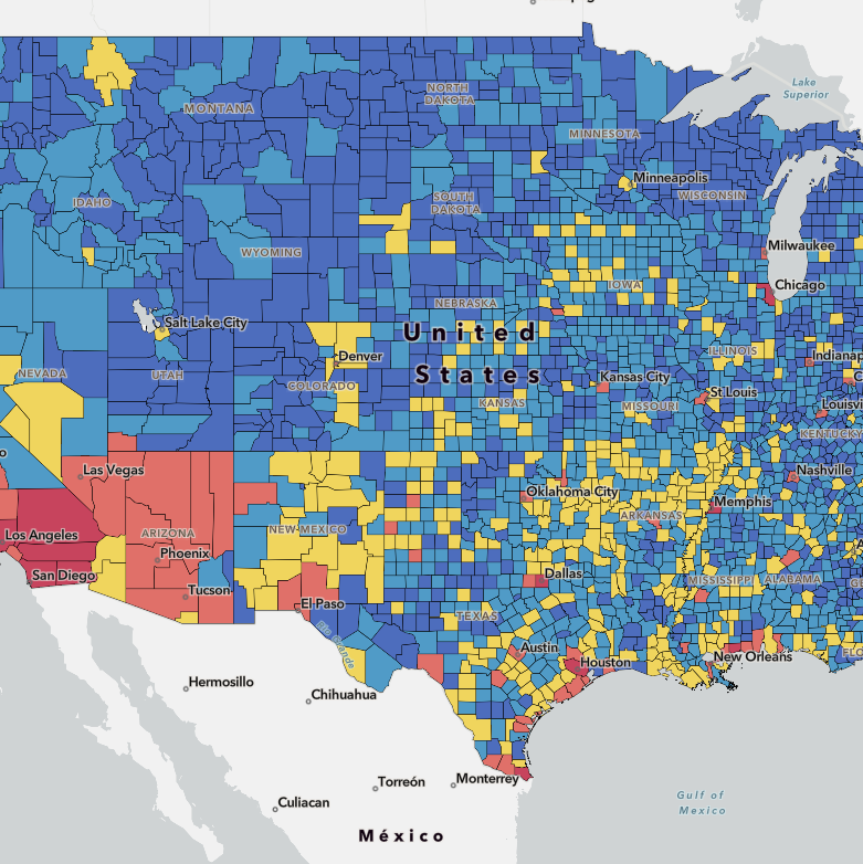
The National Risk Index is an online tool that visualizes community-level risk. It’s the first tool of its kind that identifies communities nationwide most at risk to 18 natural hazards and shows how certain factors such as expected annual losses and community resilience affect those risks.
The National Risk Index is designed to make it easier for communities themselves to be more informed of the risks they face. This tool helps communities identify and prioritize the projects most likely to mitigate disaster costs and suffering.

Get Started
Visit the National Risk Index to understand your risk to natural hazards.
- Explore the interactive map
- Learn more about your local natural hazard risk
- Access the Index's data to create your own maps and apps
Flood Risk and Endangered Species Habitat (FRESH) Mapping Tool
When you’re figuring out your community’s floodplain management program, it is important to also consider species conservation.
To learn more about reducing flood risk, lowering flood insurance premiums, and conserving species and their habitats while enjoying the benefits of naturally functioning floodplains, visit FEMA’s Floodplains and Wildlife Conservation webpage.

FRESH Maps
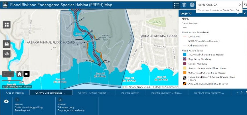
The Flood Risk and Endangered Species Habitat (FRESH) mapping tool lets you enter a street address and learn more about what threatened and endangered species and critical habitat may be at that location.
Understand Your Property's Unique Flood Risk
FEMA has spent decades investing in high-quality data to help inform flood risk and set flood insurance rates. The flood insurance premium methodology uses that data to get a better understanding of a single property’s unique flood risk, which helps set pricing flood insurance premiums.
The flood insurance premium methodology uses several flood risk variables when considering risk, including:
- Distance from flooding source
- Flood frequencies beyond the 1% annual chance flood event
- River overflow, storm surge, coastal erosion, heavy rainfall, and property characteristics (such as distance to water source, elevation, and the cost to rebuild).
Defining Risk
Watch the video to learn more about how flood variables impact your flood risk, and cost to insure.
Identifying Risk
It is important to identify your risk. When working to understand and address a property’s flood risk, you may want to consider contacting an insurance agent at a participating National Flood Insurance Program provider to find out how this relates to your specific property. Based on what you learn, you may decide if insurance is the best protection for your investment.
The Reduce Flood Risk tool can also help you find ways to reduce your property's flood risk. Using this tool, you will answer a series of five questions, and receive a detailed list of mitigation options recommended to reduce flood risk.
This section contains references and links to non-federal resources and organizations. This information is meant solely for informational purposes and is not intended to be an endorsement of any non-federal entity by FEMA, the U.S. Department of Homeland Security, or the U.S. government.
Take Action to Reduce Your Risk
There are many things you can do now to reduce the risk to your family and property from flooding.
Activities to Help Reduce Risk for Your Home
Whether you're integrating into current community plans or looking for ideas on how best to implement, our collection has numerous resources to help:
- Bring hazard mitigation into local planning
- Collaborate with local partners in my community
- Protect my home from natural disasters
- Get ideas for mitigation activities
Browse Collection of Risk Reduction Activities
Buy or Build Outside of High-Risk Zones
Reduce your risk from flooding by buying or building outside of high-risk flood zones (areas beginning with the letters A or V on FEMA flood maps) or consider making changes to your home to protect it against future floods.
Learn more through the following resources:
- Section 3.1.1 in Homeowner’s Guide to Retrofitting: Six Ways to Protect Your Home from Flooding
- Desk Reference: Substantial Improvement/Substantial Damage
- Building Science Publications: Protect Your Property from Flooding
- Brochures: Protect Your Property From Natural Hazards
- Brochure: Protect Your Property from Storm Surge
Be Prepared
Make sure you have a plan and supplies in place for when a flood happens. Visit the Ready.gov Floods page to learn what to do before, during and after a flood to keep you and your family safe.
Buy Flood Insurance
Even if you are not located in a high-risk flood zone, remember that flooding can happen anywhere. One of the best things you can do when preparing for flooding is to buy flood insurance.
Flood insurance is available to all property owners, renters, and business owners —even properties outside of the high-risk areas. To get more specific information about your property’s flood risk and the coverages and cost of flood insurance, please contact an insurance agent.
Learn About Historical Risks
Learn about historical flood risk and costs by viewing historical flood impact data to see how floods have impacted your state, according to data from the National Oceanic and Atmospheric Administration (NOAA) Storm Events database.
Consider Coastal Risks
If you live in a coastal area, you should consider protecting your home against coastal erosion.
Contact Your Floodplain Administrator
Before making changes to your home, contact your community's floodplain administrator (often an official in the zoning or planning department) to understand building and permitting requirements in your community. They can also provide information about federal and state grants and funding that may be available to help you too.

